Lost Worlds of the Atlantic 1 – Middle Earth
[hr]
In this post I will identify the geographic location of J.R.R. Tolkien’s lost world of Middle Earth.
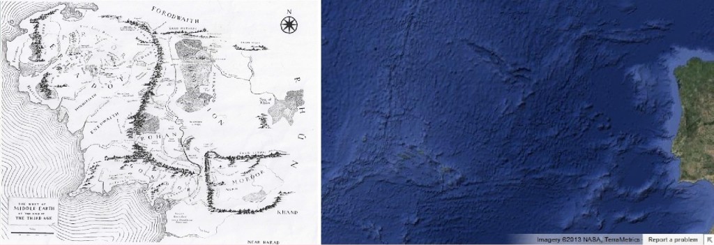 This split map shows a copy of one of Tolkien’s maps of Middle Earth on the left and on the right, a Google map of the ocean floor just west of Portugal, Spain, and France, and south of the U.K.
Most people who know of Middle Earth probably believe it to be a fictional setting created by the author entirely in his imagination. Avid Tolkien fans know that the author always said that Middle Earth was a real place that existed very long ago and was the setting of the ancient Norse folktales which he studied and preserved. Many of these avid fans also believe that Tolkien’s “Numenor” and Plato’s “Atlantis” are actually one and the same.
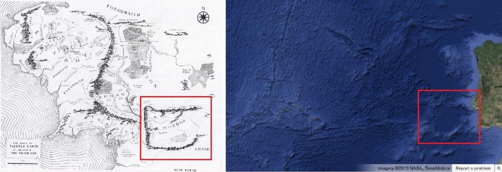
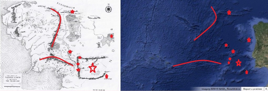
Beginning with the Tolkien map, note the unique shape of Mordor, a nation totally enclosed by a ring of mountains. A similarly shaped mega feature is visible on the Google map on the right.
On Tolkien’s map, there is a smaller ring of mountains on the northwest corner of Mordor, and likewise there is one on the northwest corner of the shape on the Google map. (shown in red circle)
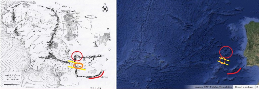
On the west wall, in most versions of Tolkien’s maps, there are one or two passes and an askew mountain that appear in various different configurations. On the Google map there are two lowland passes and an askew mountain on the west wall. (passes are shown as yellow lines/ askew mountain is shown as an orange circle)
On the south wall of both maps a southern droop in the wall near the southeast corner is obvious. (red curved line)
The unique overall shape of Mordor, along with the specific features of Mordor, being present on the Google map makes a fairly strong case that this is the place.
The location of other unique features that are outside of Mordor, found in the same relative positions in which they appear on Tolkien’s map provides additional evidence:
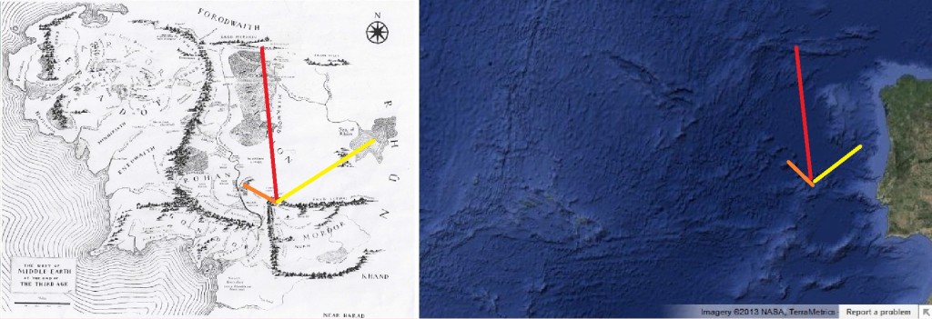
From Udun, (the small ring on the northwest corner) on Tolkien’s map, an orange line moves northwest a short distance to Emin Muil and the falls at Raros. On the Google map a similar lone stand of mountains sits at that position.
On the Tolkien map, again from Udun, a red line moves north (approximately 2X the width of Mordor) till it reaches a range of mountains moving from west to east and opening like two fingers… the Grey Mountains. On the Google map the same basic feature sits in the same relative position.
Again from Udun, on the Tolkien map, a yellow line moves east-northeast and reaches the Sea of Rhun and the three cornered forest behind the Sea, on the Google map the lines leads to a canyon that provides a reasonable explanation as to why the forest is always shown with three corners on Tolkien’s maps (on all versions of the maps that I have seen). Either the walls of the canyon were too steep or rocky to support tree growth or the tree line in those times was below the Ice Age climate of the continents.
On the Tolkien map, there are two mountain ranges of Middle earth, one curving down through the center and the other running across the south from Mordor to the west. They are visible on the Google map, but, without ocean depths, not so clearly as to be considered to definitely be mountains.
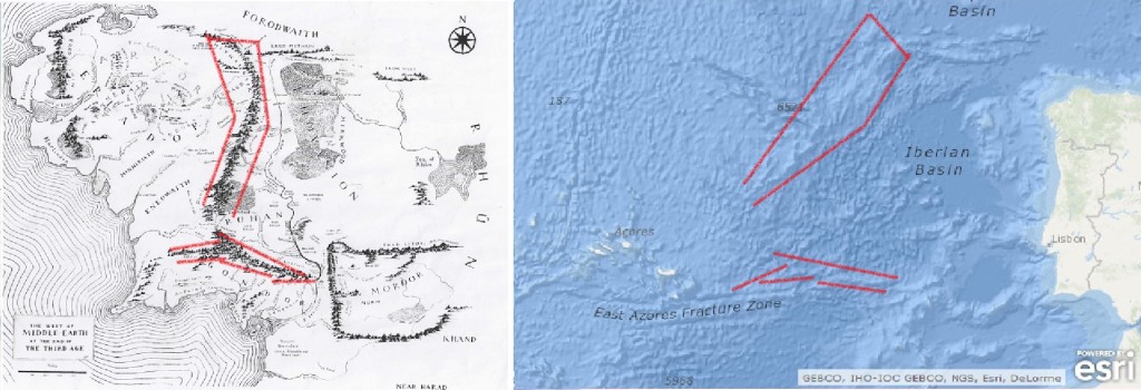
On the ocean base map found at ARCgis.com, ocean depths are available as readings that show the ocean depth in meters below sea level. After zooming in on areas to check water depth I determined that the differences between the peaks along the range and the lowlands on either side to be roughly between 2000 and 4000 meters…definitely mountains. The mountains running across the south are smaller than the central ridge, but they are still mountains.
The only features that are not similar are features that are on the Google map but do not show up on the Tolkien map. These problem areas are; the mountains running southwest from the southwest corner of Mordor, and the Mid-Atlantic Ridge, west of Middle Earth.
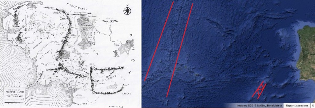
As for the mountains coming off the southwest corner of Mordor, the area to the south of Mordor seems to be drawn as a land that is desolate and about which little is known. Remember, if an area was not described in one of the tales, then the Tolkiens would not have had a description of it.
The Mid-Atlantic Ridge is different. This would have been a large ridge of high mountains compared to the lands of Middle Earth, but instead a sea is supposed to have been to the west of Middle earth. This problem is discussed in more detail in Lost Worlds of the Atlantic part 3- the Geology.
This Tolkien map of Middle Earth, drawn from descriptions, is more similar to this Google map of the ocean floor than many of the early maps of the “New World” are to North America; and considering the many points of similarity, I believe the resemblance to be beyond the possibility of coincidence.
The main thrust of this post and the accompanying video is that a comparison of the details on Tolkien’s map of Middle Earth to the features on the Google map shows too many similarities to be coincidental. Therefore, the only reasonable explanations are either: that this site is the site of the real Middle Earth, or, that this site is the site used by the Tolkiens as the setting for Middle Earth in their novels, or, that the author J.R.R. Tolkien produced the maps from his imagination in which case, I would consider him to be a psychic who could rival the famous Edgar Casey.
Personally, I believe this is the site of Middle Earth. I don’t think the author had access to visual data about the ocean floor at the time of the making of his earliest maps, and I have read accounts about scientists who found standing stone architecture on hillsides in very deep water about 400 miles west of Portugal, as well as other discoveries including one recently (soon to be the subject of a National Geographic special) half a mile below the surface, off the coast of Cuba.
Coming soon to RILOPOST.com: part 2- Numenor/Atlantis, and part 3- The Geology


Quite! This was an extremely wonderful article. Thank you for supplying these details.
Can you tell us more about this? I’d want to get information details.
http://conf.ncku.edu.tw/satu/onlineForum/profile.php?mode=viewprofile&u=26384&sid=215930c247b9aa6888e28c205c72d2d9&language=
As continental drift became widely accepted during the 1960s, and the increased understanding of plate tectonics demonstrated the impossibility of a lost continent in the geologically recent past,
they are not lost continents…only areas that were elevated, pressed together, preventing them from adjusting to a smaller core for hundreds of millions of years until they gave way to gravity and sank, bending downward from the mid-atlantic ridge on each side… i believe this created the ridge which had previously been the mid-atlantic basin, of course this is my own conjecture …the geology community thinks the ridge was pushed up by convection…i hope not because if that is so then we are headed for an eruption that would dwarf the yellowstone super cauldron.
remember i did say that either Tolkien used the earliest sonar data and copied the area as a blueprint for the world he created Or he really did work the maps out from the ancient tales in which case i think this is too similar to be coincidence.
i love you!
Very well done. You should write a book.
This info reminds me of a book I was enraptured by decades ago. “The Pyramid Theory” Check it out.